The live map that turns your spectators into supporters

The Owaka public map lets all your spectators, families and sponsors follow a race live, no app to download, from any browser, in your event's colours.

The solution

Following an outdoor adventure live:
what spectators wanted, now a reality

A true media showcase, the Owaka public live map gives the audience an immersive experience and the participants reassuring tracking. Fully customisable: set up every feature and hide your sensitive data.
A trail runner with poles climbs a mountain path during a race

In sport and motorsport, the spectator experience was long the forgotten one. For years, the families and friends of participants in an ultra-trail, a rally or a classic car raid had only one option: wait by the course hoping to catch a glimpse of their competitor, or watch for the rare updates posted on social media. The Owaka public tracking platform was designed to change that experience completely, by giving everyone (spectators, families, sponsors, journalists) the chance to follow a sports race live on GPS, from their sofa or from the side of the track, without any technical constraint.

What the Owaka public live tracking interface offers is as simple as it is powerful: an interactive real-time map, available from any web browser on a smartphone, tablet or computer, with no app to download and no account to create. In a few seconds, anyone with the event link can locate their favourite participants, follow their progress, check their current speed and anticipate their estimated arrival time. For organisers, it is the tool that turns a sports event into a true live show with a worldwide audience.

With events such as the Marathon des Sables, the Titan Desert or the BikingMan races reaching international audiences of several thousand online spectators, the Owaka public map has become a communication lever in its own right for organisers who want to promote their event, build loyalty in their community and attract new commercial partners.

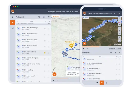
Public race map on a computer and a smartphone, with the list of participants and their live positions

For spectators

A live tracking experience that keeps your audience engaged and boosts your visibility

Owaka public live tracking is not just a page showing GPS positions. It is an interactive experience built for engagement. Spectators find a dynamic map where participants move in real time, shown by their bib numbers and category colours. Each competitor has a detailed profile that opens in one click: current speed, distance covered, position, elevation, number of checkpoints passed.

The favourite participant feature is especially popular with families and friends. By adding one or more competitors to their favourites, spectators find them at a glance, highlighted on the map and grouped in a dedicated list. No account needed: favourites stay saved in the browser from one visit to the next.
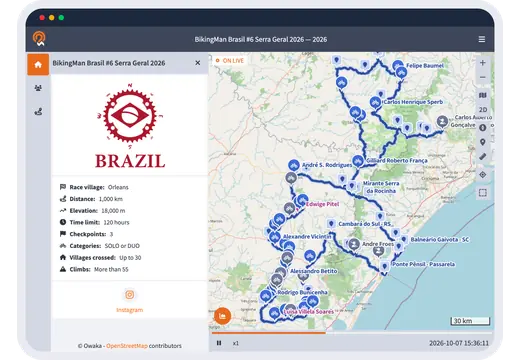
Public race map with the event details and participants live along the course

For participants

The public map as a safety and performance tool for competitors

While the public GPS tracking platform is first and foremost a showcase for spectators, it is also a valuable resource for the participants themselves, before, during and after the race. Knowing that loved ones can follow their progress in real time is a real psychological safety factor, especially on long, isolated or physically demanding events.

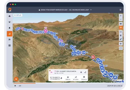
After the race, each participant can open their own profile on the public map to review their full GPS track, their performance statistics (average speed, top speed, moving and stopped time) and their elevation profile. With the replay, they relive their race stage by stage and share the link to their profile with their loved ones.

3D replay map of a Titan Desert stage in Morocco, with participants along the course

Customisation

Your public live map, customised to your wishes and needs

The Owaka public map is not a generic interface with your logo simply stuck in a corner of the screen. It is a custom showcase that reflects your race (main logo, sponsor logos, event information, external links, shared data) designed for your event with our experts.

From the map's home page, spectators discover a complete presentation of the event: dates, distances, elevation gain, cut-off times, links to your social networks and your official website. During the race, a live ranking by category can be shown alongside the map, and you choose which data is made public: tracks, statistics, past stages or replay.

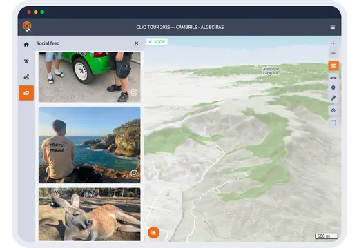
Race map next to the feed of photos posted by participants

Social Feed option

Turn the map into a community hub with the Social Feed

For events with an active community on social media, Owaka offers an optional feature that takes the live showcase even further: the Social Feed built into the public map. By connecting your event's official hashtag to the platform, the photos and videos posted by participants, spectators and official photographers appear directly on the map, in real time, side by side with the GPS positions.

In practice, a spectator on the public map sees at the same time the runners' positions on the satellite map and the photos of the landscape posted on social media by those crossing it. The event tells its story live, in pictures, and every post brings your official accounts to life.

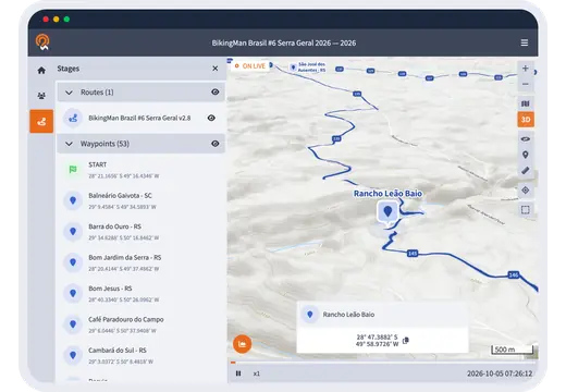
3D race map with the list of stages and waypoints

Communication & ROI

The public map as a selling point for your sponsors

Beyond its value for spectators, the Owaka public map is a concrete selling point in your partnership talks with sponsors. Embedded on your official website, seen by several thousand unique spectators during the race and available as a replay all year round, it offers premium exposure that few event communication tools can match.

Your sponsors' logos and links appear directly on the map, in an interface your spectators browse actively and at length, unlike the advertising banners they no longer look at. Every visit becomes a chance to showcase your partners, during the race and in the replay.

Frequently asked questions

Frequently asked questions about the public map

How do I follow an outdoor adventure live on GPS?

Just open the link to the event's Owaka public map in any web browser, on a smartphone, tablet or computer, with no app to download and no account to create. You will find the real-time positions of every participant, their current speed, the checkpoints they have passed and the live ranking by category.

Can I follow a specific participant on the public map?

Yes. The search and favourites features let you single out one or more participants and follow them first on the map. Each participant can also share their own personal tracking link with family and friends: a unique URL that opens the map centred on their position.

How do I add a live GPS tracking platform to my sports event website?

Owaka gives you a simple iFrame code to copy and paste into your website. The map then appears directly on your page, responsive on every device, without spectators having to leave your website. Integration only takes a few minutes and our team helps you if needed.

Is the public map still available after the event?

Yes. The public map stays online after the race with all the replay features: positions, tracks, rankings and statistics for each participant. It becomes a permanent archive of your event, available all year round and ready to showcase in your communication.

Free demo

See your event come to life on the map

In 30 minutes, our experts show you a demo of the public map. You leave with a clear picture of what your spectators will see on race day.

  • Reply within 24 h
  • No commitment
  • Free demo run by our team