Race control: your real-time control tower

Owaka race control is the GPS tracking platform built for outdoor sports event organisers. Manage safety, supervise every participant and run your race from a central dashboard, available on all your screens.

The solution

The GPS tracking platform for every race organisation

Our all-in-one platform turns your field data into strategic insights, for completely smooth organisation and full control of your event.
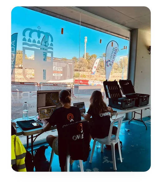
Two Owaka team members follow a race on their laptops near the finish line

Organising an outdoor sports event means managing dozens, hundreds, sometimes thousands of participants on courses often far from any infrastructure. Mountain trail running, rallies in the Moroccan desert, motorbike raids in Africa, self-supported cycling races on the other side of the world: each discipline brings its own safety and logistics constraints. Owaka race control was designed specifically for these needs: a private real-time tracking platform, built by outdoor enthusiasts for organisers who cannot afford mistakes.

Since 2013, Owaka has equipped the world's biggest sports events, from the Marathon des Sables in the Moroccan Sahara to the Durango Titan Desert in Mexico, and the BikingMan races across several continents. At every deployment, race control is at the heart of the setup: a central dashboard that gives the organising team a complete, live view of all participants, staff vehicles, checkpoints and safety alerts.

Unlike a simple GPS tracking app, Owaka's private race control platform is a true event management tool built on four core pillars: participant safety, overall race supervision, live administration and performance analysis. Each pillar is designed for real field conditions, including areas without mobile coverage, where our satellite technology takes over automatically.

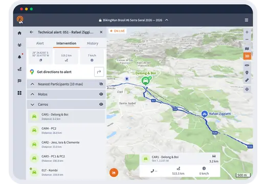
A participant's technical alert with the nearest assistance vehicles on the map

Pillar 1: Participant safety and real-time SOS alerts

Instant GPS alerts and rescue coordination

Participant safety is the top priority of any outdoor sports organisation. The Owaka tracking platform includes a real-time GPS alert system designed to cut response times in emergencies to a minimum. As soon as a participant triggers an alert from their GPS tracker, the organiser gets an immediate sound and visual notification on their platform, with the exact, time-stamped GPS coordinates of the participant in difficulty.

The Owaka satellite tracker offers three distinct alert types, each recognisable at a glance on the dashboard: medical alert, technical alert and “all good” message. Each alert follows a status (pending, resolved, cancelled) with team comments, and the intervention view lists the nearest staff vehicles and participants, with a direct route to the alert's position.
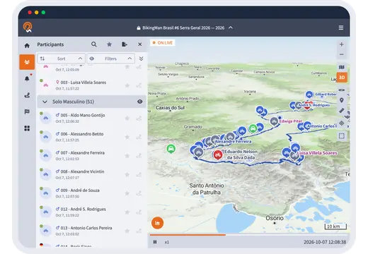
Participant list next to the race supervision map

Pillar 2: Overall race supervision and live mapping

Follow every participant, every vehicle, live

Tracking a sports or motor event in real time requires an overall view of everyone on the ground. The Owaka tracking interface gives organisers an interactive supervision map showing at once the positions of all participants, organisation vehicles, medical vehicles, checkpoints, aid stations and every course of all your races. This unified view lets you make fast, informed decisions, including in emergencies where every second counts.

List filters bring out in one click the participants who are not moving, without signal for 30 minutes, withdrawn or finished. Each tracker's battery level and inactivity time appear on its profile, and the OSM, terrain or satellite base maps suit the terrain of each stage.

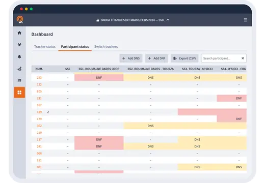
Participant status dashboard with DNF and DNS by stage

Pillar 3: Live administration and withdrawal tracking

DNS, DNF, tracker swaps and comments

Managing the administration of a live sports event is one of the most time-consuming tasks for organisers, especially when withdrawals, injuries or bib changes happen during the race. The Owaka tracking platform brings all these operations together in a single interface, available from any screen, with no particular technical skills required.

In a few clicks, the organiser can edit a participant's profile in real time (surname, first name, gender, country, category) without interrupting GPS tracking. DNS and DNF statuses are set stage by stage or for several participants at once, a faulty tracker is swapped for a spare, and the comments on each participant keep the full history of the race.

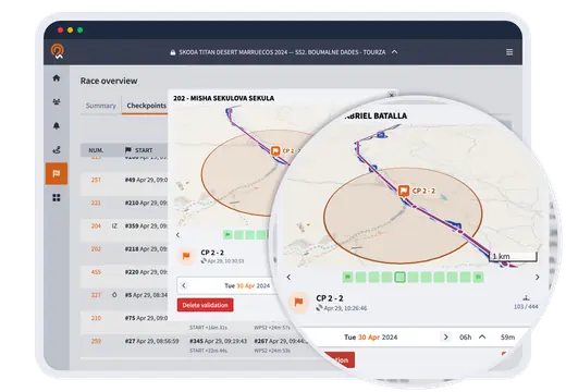
Checkpoint crossing table with a checkpoint validation on the map

Pillar 4: Performance analysis, replays and race statistics

Your event data working for your communication

The end of the race does not mark the end of race control's usefulness. The Owaka platform automatically generates a complete set of analytics as soon as the last participant crosses the line. This information is a valuable resource for several goals at once: writing official safety reports, communicating with participants and their loved ones, and promoting the event to partners and sponsors.

The post-race replay is one of the most popular features: it replays the whole race on the map, stage by stage. Summary tables give checkpoint times and speeding per zone, and the CSV export, along with each participant's GPX tracks, feeds your reports and your publications.

Frequently asked questions

Frequently asked questions about race control

What is a geolocation platform for outdoor event organisers?

A geolocation platform for organisers is real-time GPS tracking software that places every participant on an interactive map, sends instant SOS alerts with exact coordinates, and lets you run the whole event from a central dashboard and map. Owaka's live map goes further by also including administrative management (DNS, DNF, statuses), performance analysis and post-race replay.

How does real-time GPS tracking work on the Owaka race control platform?

Each participant carries an Owaka GPS tracker (GPRS 2G/4G or satellite) that sends its position at configurable intervals, from 1 second to 10 minutes depending on your needs. These positions appear instantly on your live tracking map, available on a computer, tablet or smartphone with no software to install.

Does the private platform work for events without GSM coverage?

Yes. Combined with satellite trackers, race control receives positions and alerts even in areas with no mobile coverage: the Moroccan desert, high mountains, sub-Saharan Africa. The satellite network guarantees worldwide coverage with no dead zones. You do, however, need internet access to open the Owaka map.

How many participants can the Owaka tracking platform handle at once?

The Owaka race control platform is built for events of every size, from a few dozen to several thousand participants at once. The Titan Desert, for example, has more than 500 mountain bikers tracked live over several daily stages in Morocco and Spain.

Does Owaka set up the platform specifically for my event?

Yes, that is exactly what our teams do for every event. We set up the platform with your event's name and colours, import your GPX route, define the checkpoints and speed zones, and train your team before the start. The service is fully turnkey.

Free demo

Run your next race from race control

In 30 minutes, our team shows you race control on a real event and sends you a custom quote. No commitment.

  • Reply within 24 h
  • No commitment
  • Free demo run by our team